Tsawalk and the Salish Sea

When I crossed the border into Canada on my drive to the Salish Sea Conference in Vancouver, British Columbia this past week, I got the “Q and A” by the border guard. “Where’s home? Where do you work?” I was friendly, concise and truthful. But when asked what I would be doing in Canada, I lost my cool, and enthusiastically stated, “Saving the whales!!” I got a smile and a green light. OK, not exactly true, but it seemed a good enough reason to let me spend a week in BC.

Crossing the Granville Bridge into this land of lights made me appreciate the accomplishments of the modern world. The stark mountains in the background, equaled by the skyscrapers towering in front of me, were a subtle reminder of the power of innovation and invention. It was also a reminder why I made this trip.

Granville Street Bridge

Granville Street Bridge, Nighttime Photo by Robert D. Brooks

The waters of the Salish Sea are surrounded by a highly developed landscape. Westerners, like so many cultures around the world, find ourselves inextricably connected to the water, and here we build our villages. Or, should I say, major metropolitan areas. Here in Vancouver, the interface of the modern world with the natural one isn’t lost to the madness of the city. The sea seems to shape the traffic, the infrastructure, the economy, and the culture of the area. The Straight of Georgia winds around Vancouver Island and surrounding geography like a smooth piece of velvet, buffering the noise and the commotion of the city with stillness and calm. After a closer look by the scientific community, we get a clearer picture of the problems facing these shared waters.

The Salish Sea, showing the Strait of Georgia near center, the Strait of Juan de Fuca below, Puget Sound at the lower right, Johnstone Strait at the extreme upper left, and the Pacific Ocean at lower left. Photo from Google Earth.

I learned the Salish Sea Conference used to be a science conference; a place where academics and researchers rolled out their results for other scientists and researchers to mull over, discuss methodologies, and gain ideas for their own work. I imagine the evolution into a science, policy, and management conference came about relatively quickly. What’s happening in the Salish Sea sounds alarming at best. Polluted air and water, sick and dying fish and whales, decreased habitat and spawning areas, increased marine traffic, sound pollution, invasive species, and altered eco-webs. Then, add the global threat of climate change and a world population that just hit 7 billion, and we’ve got issues. Getting back to a healthy Salish Sea ecosystem demands action, which requires those with authority to be informed. This was a message carried by the opening plenary panelists; three mayors and a commissioner from the major metropolitan cities along the coast of the Salish Sea. They need good science, and they need it now.

Whale tail, Photo by Alan Lovewell

Echoed again in the closing plenary was the plea for scientists to carry their message of an ecosystem in crisis. “We don’t know what we don’t know” a panelist said. Simply communication of knowledge, regardless of uncertainty, brings us leaps closer to effecting positive change on a large scale. Scientists were encouraged – implored, even, to have those conversations, incite those conversations, and speak until they are heard. It seems we have no choice but to make change now. As Billy Frank Jr., Native American environmental leader and treaty rights activist from the Salish region, said at conference past, “We need to all get in this canoe together. We need to start paddling in the opposite direction. And we need to paddle hard.”

Coastal Salish Plenary Panel "Working Together for the Salish Sea", photo by Erica Olson, 2011 Salish Sea Ecosystem Conference Volunteer

If nothing else, there was one message that stirred and inspired me: the idea of “tsawalk”; a Nuu-chah-nulth tribe worldview that “everything is one.” This message was threaded through several of the talks I attended.  When delivered by some of the First Nation tribes, the message became tangible and visceral: You could feel the weight of gratitude fill the room. It brought every one of us to our most basic selves. We all became simply human; fighting a battle we’ve created; fighting for our humanity with a unified understanding that without every cog and wheel, we are lost.

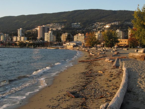
Ambleside Beach, by Lion’s Gate Bridge, photo by Hugh Shipman (gravelbeach.blogspot.com)

California Ocean Protection Council Meeting

On August 11, I had a chance to attend the California Ocean Protection Council (OPC) meeting in Sacramento.  The OPC was created, pursuant to the California Ocean Protection Act (COPA), to coordinate among agencies to solve issues facing coastal oceans. Basically, the OPC helps to break down the silos of government and to use innovative tools to tackle some of California’s toughest ocean and coastal problems.

OPC meetings, which are open to the public and webcast, are held quarterly and include a spotlight on science; this meeting focused on renewable energy.  I was especially interested to see how members of the OPC, the California Ocean Science Trust (OST), and the public interact to approach issues facing our coast and ocean.  Though my background is based more in science than policy, I worked with fishermen in Mexico and often presented my scientific findings in a similar forum.  The fishing cooperatives that I worked with in Southern Baja California Sur are all part of a larger cooperative system called FEDECOOP and each cooperative has regular meetings called assembleas where scientific information is presented, fishing policies are discussed, and decisions are made much like the OPC meetings.

This meeting’s spotlight on science focused on renewable energy and featured Dr. William O’Reilly, Senior Development Engineer at the Scripps Institution of Oceanography and Margaret Caldwell, Executive Director for Center for Ocean Solutions, who talked about the scientific and logistical needs for coastal and marine spatial planning in order to reduce conflicts surrounding existing and emerging ocean uses such as renewable offshore energy.

Dr. O’Reilly started off with a good nuts and bolts overview of different types of energy available: tidal, wave, current and wind.  I was really interested to hear there are many areas in California that are suitable for renewable energy development and it should be possible to balance the spatial needs of recreational and other ocean uses with the those of renewable energy.  Did you know that because the mass of water is about 750 times greater than that of air, the tidal energy moving through San Francisco Bay on an average day is equivalent to wind energy generated by a hurricane?  Dr. O’Reilly noted that, though it is complex to determine the potential of renewable energy sources, there is likely a lot of unharnessed energy off our shore and most importantly much of that energy is located in state rather than federal waters.  I found his report to be very optimistic about the potential for renewable offshore energy production in California.

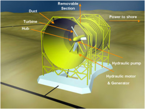
An example of a tidal energy turbine

Meg Caldwell then gave insight into the types of data and information necessary for planning for multiple ocean uses such as renewable offshore energy.  I was pleased to hear her highlight the utility of well organized, visualized, and layered geospatial data not only to inform decision making about renewable energy, but for all ocean uses and potential projects.  Caldwell explained that a system to organize these data would: provide tools to more easily implement laws and regulations, identify user conflicts, plan and permit in an efficient manner, and improve governance and transparency.  Caldwell wrapped up by pointing out the OPC can contribute by coordinating and implementing a geospatial information system by capitalizing on California OST and other scientists and experts.  This called to mind the Regional Data Network project spearheaded by the West Coast Governors’ Agreement to establish a data sharing network to improve cross boundary access to geospatial data across the west coast. This network could help connect science to stakeholders much like OPC meetings and the assembleas share science with the public and help inform decision making, as well as sharing information and lessons learned from others’ experiences.

Here is an example of geospatial data associated with a renewable energy site taken from the OR marine map website

It’s great to think we can build on ongoing efforts in other states including Rhode Island and Massachusetts when it comes to how and where to plan for renewable energy projects and other ocean uses.  I hope that meetings like these can help to solidify the thinking process and the types of information needed to move implementation of renewable energy into the forefront not just in California, but across the entire west coast in a manner that is efficient, reduces ecosystem and user conflicts, and offsets substantial portion of our current energy use.  This effort in California can especially learn from and build upon significant efforts already in progress in Oregon and Washington.

Supporting Research in the Region with a Network of Ocean Sensors

After a successful WCGA Fellows meeting, Todd, Alison, Suzanna, and I sat together for lunch at Agua Verde on the edge of Lake Union in Seattle to enjoy the Pacific Northwest summer’s delayed arrival.  We were discussing potential blog posts, when slowly an enormous research vessel emerged from under the University Bridge. Its bow towered above us in full view, and we realized it was the University of Washington’s 274-foot research vessel, the Thomas G. Thompson, returning to port. The mammoth ship dwarfed the numerous kayaks casually paddling by as we contemplated where the vessel was coming from and what it was doing.

The next day I did a little research, and discovered the Thomas G. Thompson had just returned from a very important and successful cruise on the North Pacific dubbed Visions ‘11.

The main purpose of this expedition was to aid the installation of an underwater network of sensors that remotely monitors ocean activity 300 miles off the coast of Washington and Oregon. Funded in part by the National Science Foundation, this expedition was a part of a national project called the Ocean Observatories Initiative (OOI); a collaboration of distinguished marine research institutes to move away from expensive and resource intensive ship-based research towards remote research that can provide real time data for many years.

Utilizing high-power and high-bandwidth fiber optic cables, these underwater observatories, will monitor the chemical, physical, biological, and geological processes between the ocean floor and surface. These remote “nodes” will allow scientists from around the world to conduct real time experiments to help understand deep-sea ocean dynamics. The mission, according to the OOI Science Plan Summary, is to provide practical information for a variety of uses including “fisheries management, maritime shipping and safety, public health, homeland security, tsunami warning, and weather and climate forecasting,” with emphasis on cutting-edge technology to help understand earth-ocean-atmosphere systems.

A map illustrating the size and scope of the Ocean Observatories Initiative (Image OOI)

The research vessel embarked with a crew of scientists, researchers and students interested in exploring underwater volcanoes, vents, and methane hydrate – methane gas locked in ice. Methane hydrate is getting increased attention in the energy sector as a potential fuel source to supply energy for hundreds to thousands of years.  Achievements from the cruise included video of a recent lava flow and a cable inspection captured by an underwater remotely operated vehicle (ROV)  called ROPOS.  One of the more captivating and bizarre videos the ROV took was of a foam human head and coffee cup slowly being compressed as they descended to illustrate the immense pressure at abysmal depths.

The Thomas G. Thompson with ROPOS taking advantage of calm seas (Image Visions ’11)

The three major organizations  responsible for construction and development are: Woods Hole Oceanographic Institution, Oregon State University and Scripps Institution of Oceanography . The University of Washington is responsible for cabled seafloor systems and moorings. The University of California, San Diego, is implementing the interactive infrastructure component. Rutgers, The State University of New Jersey,  University of Maine and Raytheon Mission Operations and Services, are responsible for education and public engagement software.

The observatory is scheduled to be active by 2014, at which point scientists and students alike can have access to real-time streaming data via the Internet.

The WCGA, and budding marine scientists coast wide, will be paying attention to the West Coast OOI as it unfolds, not only as a partner with the Integrated Ocean Observing System (IOOS), a federal, regional, and private-sector partnership working to enhance our ability to collect, deliver, and use ocean information, but for observational data that will inform climate change, ocean acidification, and integrated ecosystem assessments. According to the 2003 National Research Council Report a key finding states “The OOI will greatly improve the ability of operational ocean observing systems such as the Integrated and Sustained Ocean Observing System IOOS and the Global Ocean Observing System (GOOS) to observe and, predict ocean phenomena.” Furthermore, as a significant source for scientific data, it will be important to pay attention to how it connects to our West Coast regional data network that the WCGA is helping develop. The West Coast regional data network would provide access, data standards, prioritize data gaps, and data display formats to existing and future data sources at the local and state scale they are compatible at the regional scale.

Finally, I will leave you all with a poem written on the previous Visions ’05 cruise, to remind us that the scientific accomplishments of these cruises are just one aspect of the many human achievements derived from many long weeks at sea.

Ode to Duct Tape

by Ben Larson

I’m out on the ocean with nothing to do,
But build up my sensors and make them read true.
For this kind of work, I’ve got tools of all kind,
Some nice and normal, some boggle the mind.

I’ve got wrenches and drivers, both Phillips and flat,
Suppliers of power and cables that chat.
There’s tin snips and test clips and drill bits galore,
Connectors, dissectors and meters and more.

I’ve got kite twine and solder and cutters of tube,
And this guck for my o-rings, it’s some kind of lube ,
There’s lithium batteries and green circuit boards,
A funnel in case something needs to be poured.

I’ve got wire and bands, both made of titanium,
Excedrin for the occasional pain in my cranium.
There’s ICL cones and orange spiral wrap,
And computers so small, they fit on your lap.

I’ve got bungee for tying stuff down to the bench,
All manner of screws and a spiffy torque wrench.
There’s plastic zip ties for keeping things neat,
And Fiberglass sleeving, at least 90 feet.

I’ve got cylindrical cases with titanium caps,
And molecular sieves for water mishaps.
There’s sensors for chloride, $3,000 a shot,
Sometimes they work…sometimes not.

I guess you could say that’s a mighty big list,
Yet I can’t help but feel there’s something I’ve missed.
Ah, silly me, That’s it! But of course! ,
More useful than code by a fella named Morse! ,

It’s gray and it’s sticky and one side is shiny,
More than a few times, it’s rescued my hiney.
The sound when it’s peeled makes you jump off your seat,
And the scent that arises, oh what a treat! ,

It works magic and wonders in all kinds of places,
From deep ocean vents to those talkative faces,
Man’s best idea since he came from the ape,
Where would I be without my roll of duct tape.

More poems from this cruise and others can be found here along with a daily log found here.